

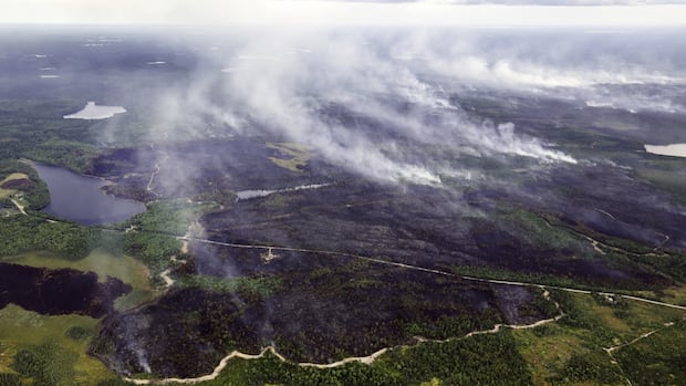
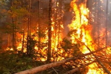
Nova ScotiaA timeline of the out-of-control Long Lake wildfire that has grown to more than 8,000 hectares, forcing over 1,000 people from their homes and damaging property in the area.Maps from the Natural Resources Department show the wildfire’s spread and evacuation areasAerial view of the northern flank of the fire and the dozer guard. (Province of Nova Scotia)The out-of-control Long Lake wildfire in Nova Scotia’s Annapolis County grew from 300 hectares on Aug. 13 to more than 8,000 hectares in less than two weeks, forcing over 1,000 people from their homes and damaging property in the area.Its rapid growth has been fuelled by the ongoing drought conditions and persistent winds, putting homes and people’s livelihoods on the line.Here’s a timeline of how the fire spread, based on maps and updates from the Department of Natural Resources: Thursday, Aug. 14 — over 400 hectaresAn evacuation order was issued the morning of Aug. 14, after the fire grew from 300 to 406 hectares — about four square kilometres.The fire had first been reported the day before south of West Dalhousie Road. Later on Aug. 14, the province released a second map showing the updated evacuation area.Saturday, Aug. 16 — approximately 800 hectaresWhile the evacuation area remained the same, the fire had nearly doubled in size by Aug. 16, reaching more than 800 hectares.Its growth was driven by shifts in humidity and wind that created extreme fire conditions, said David Steeves, a spokesperson for the Natural Resources Department, during a news conference.Monday, Aug. 18 — over 3,200 hectaresOn Aug. 18, the Natural Resources Department said the fire had grown to 3,210 hectares, or roughly 32 square kilometres, after reduced smoke the day before allowed for a more accurate assessment of its spread.It was confirmed that a narrow finger of fire had crossed West Dalhousie Road. Sunday, Aug. 24 — over 3,255 hectaresDNR released a map showing an expanded evacuation zone, now covering homes on Morse Road (between civic numbers 571 and 1073) and Thorne Road (between 4272 and 4291).Later that evening, evacuations were expanded again to include Highway 10 around Trout, Zwicker and East lakes, as well as Old Liverpool Road, Che-Boag-A-Nish Road, and West Dalhousie Road in Albany Cross.The fire had crossed Thorne Road and West Dalhousie Road in several spots and had reached as far as Paradise Lake.Jim Rudderham, DNR’s director of fleet and forest protection, told reporters that “everything in fire behaviour you don’t want happening is happening today.”Monday, Aug. 25 — over 8,000 hectaresBy Aug. 25, the Natural Resources Department reported the fire had more than doubled in size again, reaching 8,026 hectares — about 80 square kilometres.Evacuations affected more than 1,000 residents, and the province confirmed that some homes had been damaged.Tuesday, Aug. 26 — over 8,000 hectaresAt a media conference on Tuesday, Rudderham said the fire had grown again, but he did not have an updated number of hectares. Monday night brought some rain to the area, but not enough to make a significant difference. CBC meteorologist Ryan Snoddon said the Long Lake fire likely received only about three millimetres at the Milford and Greenwood stations, and eight millimetres at the New Germany station, the closest to the fire.Environment Canada cautioned that Halifax, Lunenburg, Hants and Kings counties could experience poor air quality and reduced visibility.ABOUT THE AUTHORGiuliana is a journalist originally from Lima, Peru. She is interested in stories about rural Nova Scotia, science, the environment and more. If you have any story tips, you can reach her at giuliana.grillo.de.lambarri@cbc.ca.
How the Annapolis County wildfire has grown in 13 days


