

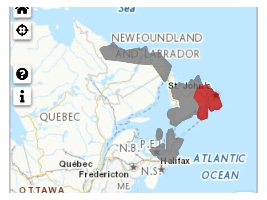
This map shows the areas of Newfoundland and Labrador where a special weather statement is in effect, while wind warnings have been issued for most of the eastern part of the island. Environment CanadaArticle contentA significant weather system is bearing down on Newfoundland and Labrador, with a special weather statement issued for most of the island and all along the Labrador coast. THIS CONTENT IS RESERVED FOR SUBSCRIBERS ONLY.Subscribe now to access this story and more:Unlimited access to the website and appExclusive access to premium content, newsletters and podcastsFull access to the e-Edition app, an electronic replica of the print edition that you can share, download and comment onEnjoy insights and behind-the-scenes analysis from our award-winning journalistsSupport local journalists and the next generation of journalistsSUBSCRIBE TO UNLOCK MORE ARTICLES.Subscribe or sign in to your account to continue your reading experience.Unlimited access to the website and appExclusive access to premium content, newsletters and podcastsFull access to the e-Edition app, an electronic replica of the print edition that you can share, download and comment onEnjoy insights and behind-the-scenes analysis from our award-winning journalistsSupport local journalists and the next generation of journalistsRegister to unlock more articles.Create an account or sign in to continue your reading experience.Access additional stories every monthShare your thoughts and join the conversation in our commenting communityGet email updates from your favourite authorsSign In or Create an AccountorArticle contentIn addition, a wind warning has been issued for the eastern regions of the island of Newfoundland. Article contentArticle contentA rapidly deepening low-pressure system approaching from the south is expected to bring heavy rain and strong winds, starting Tuesday morning, Nov. 4, and lasting until Wednesday night, Nov. 5. Article contentArticle contentMost of Newfoundland can expect around 30-50 millimetres of rainfall, with higher amounts possible in some localized areas.Article contentSt. John’s International Airport has said the weather may impact flight activity and encouraged travellers to either check directly with their airline before heading to the airport or check flight information at stjohnsairport.com.Article contentAs of late afternoon on Monday, Nov. 3, the heaviest rainfall amounts were expected to be along the south coast from Burgeo to the Burin Peninsula. The track of the storm is still uncertain, though, and any slight shifts to its tracking could influence where the heavier rains fall. Article contentAccording to the special weather statement issued by Environment Canada, similar storms in the past have caused minor flooding and poor driving conditions due to significant rain and minor damage and utility outages due to significant wind. The wind warning issued by Environment Canada is in effect for the east coast of Newfoundland and the northern Avalon Peninsula and is forecasting strong winds that could cause damage. Article contentArticle contentThe highest wind gusts are expected on Tuesday afternoon and evening. They will be easterly to southeasterly, with gusts possibly reaching 80 kilometres per hour, except 100 kilometres per hour along parts of the coast. Article contentArticle contentWinds of the same strength, but shifting to become westerly to northwesterly, are expected Tuesday night and into Wednesday evening. Article contentAccording to the warning, damage to roofs, fences, branches or soft shelters is possible and residents are urged to secure loose objects. Article contentParts of western Newfoundland that had been initially included in the special weather statement were not subject to any sort of alerts as of late Monday afternoon, though rainy and windy conditions were still expected along the west coast while the rest of the province endured the brunt of the storm. Article contentAccording to highlights provided by The Weather Network, some gusts along the southeastern coasts, including St. John’s and the Avalon may see gusts exceeding 110 kilometres per hour while wet snow may occur in higher elevations of western Newfoundland. Article content
Bombs away: Major storm headed towards Newfoundland and Labrador


