

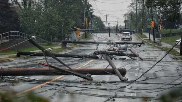
Nova Scotia·NewCanada’s weather warnings have changed to a new colour-coded, risk-tiered system implemented by Environment and Climate Change Canada. The three alert levels — yellow, orange and red — are based on the potential impacts of a weather event and the forecast confidence.New colour-coded, tier-based warnings will change how weather messaging is deliveredRyan Snoddon · CBC News · Posted: Nov 26, 2025 1:30 PM EST | Last Updated: 1 minute agoListen to this articleEstimated 3 minutesThe audio version of this article is generated by text-to-speech, a technology based on artificial intelligence.How Environment Canada’s new weather warning system worksStarting today, Environment and Climate Change Canada has changed the way it classifies its weather warnings. CBC Meteorologist Ryan Snoddon explains it’s all about risk and impact. Environment and Climate Change Canada has changed its weather warning system across the country.General watches and warnings are being replaced with a colour-coded, risk-tiered system so you have a better idea how the forecast will impact you and how you should prepare.The changes align with recommendations from the World Meteorological Association and follow updates already implemented by 31 weather agencies across Europe. The new risk-tiered system includes three different colours: yellow, orange and red. (Environment and Climate Change Canada)Environment and Climate Change Canada will continue to issue the types of warnings you normally see throughout the course of the year, including severe thunderstorm watches and warnings, rainfall warnings, snowfall warnings and wind warnings. Special weather statements are still in the mix, which appear in grey.Those statements will continue to give information about a weather event that is potentially significant or of interest, but doesn’t quite reach warning-level criteria.The difference moving forward is that each of these warnings will now have a colour-coded alert level of yellow, orange or red. The alert level will be based on an assessment of both the potential impacts of the weather event and also the forecast confidence.So the higher the impact and the higher the confidence that the incoming weather will actually deliver those impacts, the higher the alert level. Let’s talk about the colour levels and break down the impacts for you:Yellow alertsFor the majority of warning-worthy storms and hazardous events, you’ll likely see a yellow warning. The majority of warning-level snowfall events will be noted as yellow alerts. (Steve Lawrence/CBC)Yellow alerts are the baseline for watches and warnings and can be issued for a wide range of weather situations. This is the type of weather that will bring hazardous or dangerous conditions, affecting travel and causing delays or cancellations. There could be health-related impacts, like reduced air quality or heat warnings.Orange alertsOrange warnings are the next phase and will be issued for storms that are likely to cause widespread and or significant damage. Here we are talking about widespread wind storms, or crippling ice storms that cause thousands of homes and businesses to lose power for days.Orange alerts will be issued for winter storms that take a few days to completely dig out of. If an orange-level warning is issued for your area, you should prepare to take action to protect yourself and your property.Red alertsThe highest warning level is red. If a red alert is issued, it means dangerous and potentially life-threatening weather is on the way, or is occurring.Post-tropical storm Fiona, which ravaged Nova Scotia in September 2022, would be categorized as a red alert-level event. (Submitted by Lynn Arsenault)Under a red alert, you should expect prolonged and extensive disruptions to travel and power, with widespread damage to property and infrastructure. Examples include Hurricane Fiona in September 2022, or the 2024 snowstorm that brought 150 cm of snow to parts of Cape Breton, or flooding events, like the ones experienced by Maritimers over the past few years.If a red alert is issued, it means you should act now to stay safe from destructive weather. A snowstorm like the event that dumped 150 centimetres on Sydney in 2024 would be considered a red-level alert. (Joe Pembroke)By focusing on the weather impacts rather than the weather itself, the main goal is to enhance storm preparedness and better communicate how to prepare in advance. So when a warning is issued for your area, it’s important to read the content of that warning to determine which weather situation is being covered and then act accordingly. MORE TOP STORIES
Canadas weather warning system has changed. Heres how


