

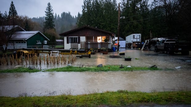
December 112 hours agoWe’re wrapping up live updates for the dayAkshay KulkarniA flooded field in the Sumas Prairie today. (Ben Nelms/CBC)We’re wrapping up live updates on this page for the evening, but officials in B.C. say residents in flood-prone areas should continue to be on standby to leave as the rain continues into the night and swollen rivers could potentially overflow.In addition, major highways between the Lower Mainland and the Interior are closed due to flooding, falling rock and debris, and avalanche risk. Drivers are encouraged to check DriveBC for the latest updates in the morning.Today saw several areas of B.C.’s Fraser Valley under water, including parts of Abbotsford and Chilliwack, triggering anxious memories of the devastating flooding in November 2021.But officials say current models don’t indicate the current weather system will lead to flooding that widespread, with just a handful of properties on evacuation order. At the same time, evacuation alerts cover significant areas of Abbotsford and Chilliwack, meaning residents should be ready to leave at a moment’s notice if conditions deteriorate.South of the border, the situation is much more severe. Washington state declared a state of emergency and officials anticipated evacuation orders for as many as 100,000 residents.We’ll have more coverage of the floods, the weather and their effects on Thursday at cbc.ca/bc.3 hours ago‘All hands on deck’ to ensure highways reopen, official saysAkshay KulkarniDriveBC says all major routes between the Lower Mainland and the Interior are closed Wednesday night. (DriveBC)In addition to the highway closures listed below, Highway 99 (the Sea-to-Sky Highway) is closed between Pemberton and Lillooet due to heavy rain and the risk of debris flows, according to DriveBC.Although officials are expecting water in the region to recede overnight, workers will be out at the crack of dawn to assess the highways and the damage, said Janelle Staite from the B.C. Transportation Ministry.“That’s our first and foremost priority as we get up tomorrow morning at first light — to make sure that we get eyes on the ground,” she said.“We recognize the criticality of these corridors … and certainly have all hands on deck to ensure we get those accesses restored as soon as we can.”3 hours agoChilliwack resident concerned about friends in SumasJohna BaylonChilliwack resident Mike Vandergugten is seen next to the Chilliwack River on Dec. 10, 2025. (Shawn Foss/CBC)I’m Johna Baylon, a CBC News reporter based in Vancouver. Earlier this evening I travelled to Chilliwack, and reported near the Keith Wilson Bridge, which crosses the Chilliwack River.I spoke to a nearby resident, Mike Vandergugten, about how he was feeling amid the heavy rains.Vandergugten moved there in January. He recalls the floods of November 2021, but after doing some research he felt confident in the upgrades the city has made to its pump stations.“I don’t see an imminent risk for where we are at, but it’s always good to be prepared,” he said, noting he has his emergency items packed and ready. However, he’s concerned about friends in the Sumas area.“It’s times like these where we want to make sure to help out our friends and our neighbors,” he said. “Maybe check on those who are elderly or immobile to make sure that you know their property is doing okay.”3 hours agoThis is different from 2021, says river forecasterAkshay KulkarniRoads were completely submerged in Abbotsford, B.C., during the November 2021 floods — but officials stress this time is different, largely due to the duration. (Ben Nelms/CBC)Connie Chapman from the B.C. River Forecast Centre says that the Nooksack River — which feeds into the Sumas River north of the U.S.-Canada border — will see levels peak around 10 p.m. PT tonight.She said it’ll stay in its peak flow state until around 4 a.m. to 6 a.m. PT, after which water levels are likely to recede.The official stressed that, while the volume of water coming from the Nooksack River is similar to that seen in 2021, rainfall is expected to ease off tonight.While the river flow may reach 2021 levels for an instant, it won’t persist for as long, Chapman explained.“We could see different scenarios, where maybe there isn’t as much impact and the flows are able to be absorbed by the surrounding watershed,” she said.3 hours agoSignificance of the Nooksack RiverDarius MahdaviFlooding of the Nooksack River in Washington state is a concern to Abbotsford, B.C., because its high waters have the potential to flow north into Canada and further inundate low-lying areas. (CBC News)Let’s talk more about the Nooksack River, south of the border.Earlier this evening, the U.S. Northwest River Forecast Center said it expected the Nooksack to reach “a similar level as observed during the November 2021 flood event.” As many Fraser Valley residents know, water from the Nooksack — which flowed in through the Sumas River — was largely responsible for flooding the Sumas Prairie that year. This is concerning, but it’s not the whole picture. Since 2021, several projects to improve flood resilience have been executed, including improved infrastructure and careful dredging of sections of the Sumas River — as officials mentioned during B.C.’s most recent news conference.Also, rainfall in the month before the 2021 floods had been well above average, saturating the soils, whereas leading into this week there’s been a relatively dry stretch. Hopefully that means the landscape has more capacity to absorb the water that’s expected to come through the Sumas River, but we won’t know for a while — there’s a decent delay, upwards of several hours, for high streamflows or flooding in the Nooksack to flow into B.C.So, even after the rain ends later this evening, we won’t be out of the woods – in fact, flood risk may not peak until Thursday morning.3 hours agoOfficials have ended the news conferenceAkshay KulkarniThe news conference, which largely focused on a swath of highway closures due to flooding, rock slides and debris, has ended.Reporters asked officials about how they’re working to support farmers and ranchers affected by the floods, as well as how they’ve learned from the 2021 floods.I’ll be folding in some more insight from officials who spoke at the news conference — specifically about how long highway closures might last, and the flood situation south of the border.4 hours agoSeveral highways closedAkshay Kulkarni⛔️ #BCHwy1 – Eastbound is CLOSED between #BridalFalls / #BCHwy9 and #HopeBC due to flooding. A travel advisory has been issued for all travel in the #FraserValley. ⚠️There is no eastbound access from the Lower Mainland to #HopeBC at this time. #BCHwy7 remains closed between…—DriveBCIn addition to the earlier-announced closure of Highway 7 west of Hope, Highway 1 will be closed eastbound at Bridal Falls, between Hope and Highway 9, due to a significant amount of water, says Janelle Staite from the B.C. Transportation Ministry.Highway 3 will be closed in the Allison Pass area due to a debris fall that’s blocking a culvert, she adds.The critical Highway 5 or Coquihalla stretch between Hope and Merritt is also closed due to flooding along the corridor.In addition, Highway 1 through the Fraser Canyon has been closed due to high avalanche risk.“Access right now between the Lower Mainland and the Interior is limited,” Staite acknowledged.4 hours agoRoads from Lower Mainland to B.C. Interior closed: ministerAkshay KulkarniOfficials have begun their update on the flood situation in southwest B.C.Emergency Management Minister Kelly Greene says road access to the Interior from the Lower Mainland will be closed, in order to provide space for evacuees and emergency responders.She says a travel advisory has been issued for areas of the Fraser Valley, and people are being asked to avoid travel unless absolutely necessary.4 hours agoHigh water levels on Sumas RiverDarius MahdaviThis graph shows water levels on the Sumas River near Huntingdon, close to the U.S.-B.C. border, around 8 p.m. PT on Dec. 10, 2025. (Water Office/Environment Canada)I’m Darius Mahdavi, CBC’s science and climate specialist based in Vancouver.Some things to watch tonight are water levels and discharge on the Sumas River, which carries water from the Nooksack River up into B.C. The graph here shows the hydrometric data from the station on the Sumas River near Huntingdon, on the Canadian side of the border. Water levels are currently around 3.25 metres – well above the normal levels of about 1.5 metres, but still well short of the approximately 4.2-metre water level we saw during the 2021 floods.Many officials will be watching this station closely overnight, and through much of tomorrow, to see how much higher these numbers climb.4 hours agoProvincial officials to provide ‘urgent’ updateAkshay KulkarniB.C. Emergency Management Minister Kelly Greene, seen here earlier this year, is set to provide the update. (Ben Nelms/CBC)B.C. officials will be providing an “urgent” update on the flooding situation at 8:30 p.m. PT.Emergency Management Minister Kelly Greene will be attending, along with technical experts from the provincial River Forecast Centre. It will be streamed online.
Flooding in parts of B.C.s Fraser Valley leads to major highway closures, state of emergency


