

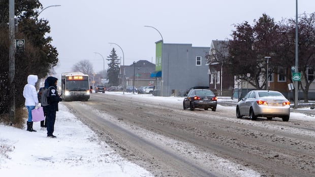
Kitchener-WaterlooTwo different weather systems are bringing winter conditions to Ontario and Quebec starting Wednesday and into Thursday, with heavy snow and high winds expected.’Travel will likely be hazardous. Road closures are possible,’ Environment Canada warnsKate Bueckert · CBC News · Posted: Nov 26, 2025 11:58 AM EST | Last Updated: 1 hour agoListen to this articleEstimated 4 minutesThe audio version of this article is generated by text-to-speech, a technology based on artificial intelligence.People wait for a bus in Thunder Bay on Wednesday morning as snow started to fall. The area is under a winter storm warning with up to 20 cm possible. People in northern and southern Ontario and parts of Quebec are bracing for snow and high winds that are expected to begin Wednesday afternoon or evening and continue into Thursday. (Marc Doucette/CBC)People in parts of Ontario and Quebec will want to have shovels and tuques at the ready as two different weather systems are expected to dump between 10 to 60 cm of snow on parts of both provinces over the next few days.In northern Ontario, Environment and Climate Change Canada has issued a winter storm warning starting Wednesday, with up to 60 cm of snow possible in some areas.The warning, along with poor visibility on the roads due to wet and heavy snow, led to the closure of some rural schools and cancelled buses in the Thunder Bay area on Wednesday.The Ontario Provincial Police reported Highway 144 was closed near Timmins due to severe weather and drivers were being advised to avoid travel unless necessary.The warning says peak snowfall rates of four centimeters per hour are possible and people may experience almost no visibility due to heavy and blowing snow.“Strong northerly winds gusting up to 70 km/h will accompany the snow,” the warning said. “Travel will likely be hazardous. Road closures are possible.”The winter storm warning stretches from Lake la Croix across the northern shore of Lake Superior, north to Moosonee and the tip of James Bay, then east into Quebec and the area around Lake Mistassini. Where the winter storm warning ends in Quebec currently, there is a special weather statement in effect warning people in areas including Manic, Baie-Trinité, Sept-Îles-Port-Cartier and Labrieville areas that snow is on the way Wednesday night into Thursday evening, with up to 15 cm possible.Snow and high winds in southern OntarioMeanwhile in southern Ontario, a different weather system is set to bring snow and high winds to the area stretching from Windsor to Kingston.Lake effect snow is expected in the counties of Huron, Grey, Bruce, Simcoe Wellington and Waterloo region. A snow squall watch is in effect for snow expected to fall overnight Wednesday to Thursday morning with up to 30 cm possible, even up to 50 cm for people closer to Lake Huron. “Snow squalls will shift throughout the day on Thursday before locking in place Thursday night. Strong winds are also expected for some locations,” the snow squall watch said.A special weather statement is in effect for all of southern Ontario including Toronto and east to Kingston for strong winds up to 90 km/h.“Local utility outages are possible. High-sided vehicles will be pushed around by the wind. Loose objects may be tossed by the wind,” the statement said.Norfolk and Haldimand counties and the Niagara region along the north shore of Lake Erie are under a wind warning starting Wednesday afternoon. The warning says winds will “ease” to 70 or 80 km/h Thursday morning.A wind warning is also in effect for areas near Lake on the Mountain Provincial Park on the north shore of Lake Ontario.Take extra precautionsEnvironment and Climate Change Canada meteorologist Steven Flisfeder told CBC News people should be aware of travel conditions before leaving their homes.”Make sure you’re taking extra precautions if you’re heading out on the roads, so keeping safe distances, giving yourself extra time to get to where you’re going to travel,” Flisfeder said.“Travel is likely to be impeded as a result of those visibility issues, so keep that in mind if you have to be out on the roads Thursday through Friday.”ABOUT THE AUTHORKate is the content producer for CBC Kitchener-Waterloo. She has been covering issues in southern Ontario for more than 20 years. Reach her by email: kate.bueckert@cbc.ca.
High winds expected around Prince Edward County during double storm


