

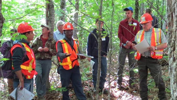
New BrunswickA team of researchers in New Brunswick is using satellite technology and artificial intelligence to help foresters identify and avoid cutting old forests that provide critical habitats to species like bats and chimney swifts. Data will be used to create a live map for foresters, identifying areas to avoid harvestingIsabelle Leger · CBC News · Posted: Oct 12, 2025 5:00 AM EDT | Last Updated: 3 hours agoThe team at the Northern Hardwoods Research Institute in Edmundston is spending 18 to 24 months using satellite tech and AI to build useful tools to keep critical habitats in old forests from harm. (Submitted by Jennifer Saunders )A New Brunswick-led research project is using satellite imaging and artificial intelligence to find and predict where old forests are, in an effort to develop better management practices for the forestry sector. Northern Hardwoods Research Institute is leading the project, with funding from the Canadian Space Agency, from its Edmundston facility. The team will use data from satellites that fly over the same forested area each week.Gaetan Pelletier is the institute’s executive director. He said the goal is to provide forestry managers with the tools to protect old forests that have rich and complex ecosystems crucial to the survival of some species. “They are special ecosystems and today we’re not equipped with the technology or tools to find out where they are before we enter an area and conduct harvesting,” Pelletier told CBC Radio’s Information Morning Fredericton. Old forests provide critical habitats for certain species, but Gaetan Pelletier, the executive director of Northern Hardwoods Research Institute Inc., says foresters and forestry managers aren’t equipped with tools to identify those habitats until it’s too late. (Submitted by the Northern Hardwoods Research Institute )“We’re able to not only find old forest types, but also see the change over time,” said Pelletier. He said the satellites being used have about 10 sensors on them to collect data. That will help the team track dead trees, windfalls and trees that are hollow and being used as habitats for certain species. While there are many species that rely on old forests, Pelletier said the chimney swift is likely the best known. That’s a bird that will occupy chimneys in urban areas, or hollow trees in the wild. “You see them actually [in] downtown Fredericton in old standing chimneys… but the bird also likes recently dead and hollow trees, which they use to dwell and roost,” said Pelletier, calling old forests “a critical habitat for that species.” LISTEN | Research executive explains need for tools to identify old forests in the wild:Information Morning – Fredericton10:01Satellite forestsA New Brunswick research centre received funding from the Canadian Space Agency to use satellite imaging to identify old forests so they can be protected. Colleen Kitts-Goguen spoke to Gaetan Pelletier, executive director of Northern Hardwoods Research Institute in Edmundston.He said two layers of data will be collected using the satellite technology: one to identify large forested areas with the likelihood of having hollow trees, and another to pinpoint specific hollow trees. In the future, harvester machines can be equipped with live maps on the navigation computer that will be informed by the data.“We can mark those trees for the navigator and say. ‘Hey, watch out here. Maybe you want to maintain a 30-metre buffer because we think there is a hollow tree being used by chimney swifts and brown bats and other species’,” said Pelletier. Gaetan Pelletier says the satellites providing data to the research project have about 10 sensors and capture images of the same area each week. The goal is to provide foresters with a live map that flags specific areas and even certain trees to avoid cutting. (Submitted by Northern Hardwoods Research Institute)The project will span from 18 to 24 months, but Pelletier said the team wants to start providing solutions for testing by March 2026. The goal is to have prototype map data completed and ready for use by foresters across New Brunswick by next fall. This was one of 20 projects across Canada that received funding from the Canadian Space Agency. The Northern Hardwoods Research Institute received $250,000 in grant funding from the agency and estimates the project will cost $500,000 in all. ABOUT THE AUTHORIsabelle Leger is a reporter based in Fredericton. You can reach her at isabelle.leger@cbc.caWith files from Information Morning Fredericton
N.B. researchers use satellite tech and AI to identify critical habitats in the wild


