

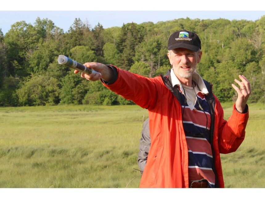
Article contentLaurin said he would be honoured if the mill was found on his land.Article content“We have preserved some of the oldest elements of our Canadian and continental history. This is the birthplace of French America,” he said. “It’s a huge, huge door that opens up suddenly to the history of the French in North America and Europeans in general.”Article contentArticle contentGetting startedArticle contentIn 2022, an Apple River, Cumberland County, resident sent Borton a copy of Samuel de Champlain’s map of Port Royal. Borton, a Connecticut resident with a passion for mills and tides, went to Google satellite images and came across something that was about 25-foot square in the marsh. He thinks it is the location of the first mill.Article content“Over there in the corner,” Borton said pointing towards a tree, “that’s where it ought to be.”Article content Mark Borton points to a corner of the marsh along the Allains River in Lequille during a June 16 presentation on Jean de Poutrincourt’s 1607 grist mill. Photo by Jason Malloy /Annapolis Valley RegisterArticle contentBorton has applied for and received a Nova Scotia archeological reconnaissance permit. He submitted a 400-page report and was given the approval to continue with his group’s work.Article contentArticle contentLaurin said he was shocked by what he was hearing during the initial call with Borton.Article content“Wow,” he said. “It opened up a complete new chapter to our understanding of what has happened here.”Article contentArticle contentBetter understandingArticle contentHe now walks on his property and sees the different potential sites Borton points out, including another grist mill and a saw mill – both dating back to the late 1600s.Article content“I can envision a functional village here,” Laurin said. “You don’t need a whole lot of imagination to picture a mill.”Article contentLaurin was an interpreter at Fort Anne National Historic Site 30 years ago and now operates Novacadie Tours. The Woodville resident has owned the property west of the Lequille Hydro Plant for 20 years. He purchased property across the road from the plant, overlooking the marsh, about six years ago.Article content“I fell in love from the start,” he said of the properties.Article contentArticle contentArticle contentSharing the detailsArticle contentAfter working quietly behind the scenes, the group’s quest for clues has become public. The County of Annapolis hosted an event June 16 at the hydro plant, in conjunction with the Pierre Dugua, sieur de Mons, celebrations, and Borton and Laurin explained more about the collaborative research project.Article contentBorton and Laurin spoke to about 40 people at the county event before going across Dugway Road and pointing out specific locations in Borton’s hypothesis.Article content“We’re dealing with a mystery that has been around for 400 years,” he said.Article contentA big part of the uncertainty is corporate lawyer Marc Lescarbot and Champlain, the cartographer, were part of the original expedition team in 1604-1605. They both saw the mill at the same time, but drew it on different sides of the river on their maps.Article content“We’re peeling back the history, using modern tools,” Borton said, noting it includes satellite imaging and lidar. “We now think we know where the sites are. We now have to qualify, verify, those sites.”
Pointing out potential site of Poutrincourt’s 1607 mill


