

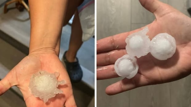
ManitobaHail and thunder pounded parts of southern Manitoba and forked lightning flashed in the sky like “disco lights” as a series of summer storms roared through Wednesday overnight into Thursday.More than 100 mm of rain fell in Portage la Prairie and areas nearbyDarren Bernhardt · CBC News · Posted: Aug 21, 2025 12:55 PM EDT | Last Updated: 1 hour agoThese large hailstones fell in Notre Dame de Lourdes, southwest of Portage la Prairie, on Wednesday night. (Submitted by Mariela Meza)Hail and thunder pounded parts of southern Manitoba and forked lightning flashed in the sky like “disco lights” as a series of summer storms roared through Wednesday overnight into Thursday.”Many people in the city are probably groggy-eyed waking up this morning, talking about [their lack of sleep]. We definitely had a lot of rain last night, hours and hours of lightning and thunder,” said Environment Canada meteorologist Crawford Luke.”These storms basically just kept reforming and reforming and reforming basically between Winnipeg and Portage [la Prairie].”Rainfall totals in Winnipeg ranged from 15 millimetres on the east side of the city to nearly 60 mm on the west side. The greatest amounts were recorded around the Portage la Prairie area, with that city and nearby High Bluff both getting 101 mm.”It’s basically like more than a month’s worth of rain — almost two months’ worth of rain — falling overnight,” Luke said.A pile of hail is scooped up by Dawn Kautz Nee Bohncke at her home in Kleefeld, south of Winnipeg. (Submitted by Dawn Kautz Nee Bohncke)Further south, toward the international border, the totals drop off to about one or two millimetres, except for some locations southeast of Winnipeg, where 32-75 mm were recorded.That data comes from the Community Collaborative Rain, Hail and Snow Network, CoCoRahs, a network of citizen volunteers who measure weather data, from which Environment Canada gathers reports. High Bluff — 101 mm. Portage la Prairie — 101 mm. Poplar Point — 98 mm. Sanford — 94.2 mm. Starbuck — 91.2 mm. Zhoda — 74.6 mm. Elie — 72.4 mm. Brunkild — 66.2 mm. St. Norbert — 49 mm. Steinbach — 41.5 mm. Winnipeg (Westwood) — 58.7 mm. Winnipeg (Whyte Ridge) — 49.5 mm. Winnipeg (St. James) — 31 mm. Winnipeg (downtown) — 30 mm. Winnipeg (Transcona) — 15 mm. “We also have numerous reports of loonie-sized hail, toonie-sized hail, even some golf ball-sized hail … two-, three-, four-, five-centimetre-diameter hail, so quite sizeable — certainly capable of denting cars and causing other damage like that,” Luke said.Some of the rainfall totals totals across southern Manitoba. (Riley Laychuk/CBC)Dawn Kautz Nee Bohncke, who was scooping up handfuls of hailstones off her property in Kleefeld, south of Winnipeg, said her squash and pumpkin leaves are in tatters, and there are definite dents on the family vehicles.In a Facebook post, Kautz Nee Bohncke described the storm as “disco lights” and said her area was “hammered with the loudest and longest hail I’ve experienced.”So far, Environment Canada hasn’t received any reports of tornadoes or even funnel clouds, Luke said.”But reports could be trickling in throughout the day. We might learn something later,” he said. “Right now it looks like just a bunch of hail reports and a lot of rain.”The stormy weather began forming around 9:30-10 p.m. and kept rolling through to about 6 a.m., Luke said.”Just going through the radar even right now, it’s really impressive. We call this back building or training … when thunderstorms kind of reform over the same area over and over again.”Those are the types of storms that lead to flash flooding, though no reports of that have come in, Luke said.There were a number of power outages reported by Manitoba Hydro across the path of the storms, but crews were expected to have things back on by noon Thursday, a spokeserson said.Possible relief in fire zonesThere’s a 30 per cent chance of rain for Portage la Prairie and Winnipeg on Thursday and Friday, with gusting winds, but nothing like what just passed through is expected again, Environment Canada forecast.The northern part of the province, however, could be in for a downpour that could soak many of the areas that have been bone dry and afflicted by wildfires.”We sure hope so. We’ve actually had a few systems go through the north in recent days, particularly on the Saskatchewan side, which did help with the fire situation there,” Luke said.”So we’re certainly hoping that it’s going to improve the situation in Manitoba this time. It looks like a lot of these areas should get in on the rainfall.”The rainfall warning from Environment Canada includes Flin Flon, Leaf Rapids, Lynn Lake, Pukatawagan, Snow Lake, Split Lake, Thompson, Shamattawa, Nelson House and Gillam.”It seems like everyone in the north is going to get at least some rain from the system, even if they don’t get quite as much as the warned regions,” Luke said.”I would assume that can only be good news for fires.”ABOUT THE AUTHORDarren Bernhardt has been with CBC Manitoba since 2009 and specializes in offbeat and local history stories. He is the author of two bestselling books: The Lesser Known: A History of Oddities from the Heart of the Continent, and Prairie Oddities: Punkinhead, Peculiar Gravity and More Lesser Known Histories.With files from Meaghan Ketcheson and Erin Brohman
Storms clobber southern Manitoba with piles of hail and brilliant lightning display


