

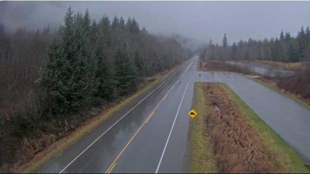
British ColumbiaEnvironment and Climate Change Canada has issued rainfall warnings for a stretch of the coastal region that includes Bella Coola to Kitimat, and expanded a snowfall warning for northwestern B.C.Up to 70 millimetres of rain forecast for north-central coast Thursday, snowfall warning expanded in northwestThe Canadian Press · Posted: Nov 20, 2025 4:00 PM EST | Last Updated: November 20Listen to this articleEstimated 3 minutesThe audio version of this article is generated by text-to-speech, a technology based on artificial intelligence.A highway camera shows heavy rainfall on Highway 16 east of Prince Rupert. Rainfall warnings are in place just south of the area on Thursday. (DriveBC)B.C.’s north and central coast could see up to 70 millimetres of rain as a frontal system sweeps through the region on Thursday, with forecasters saying a wet weekend is also on the cards for the South Coast.Environment and Climate Change Canada has issued rainfall warnings for a stretch of the coastal region that includes Bella Coola to Kitimat.The weather office says the heavy rainfall could result in washouts near local rivers and creeks, as well as water pooling on roads.The rain is expected to taper off by Friday.Environment Canada also expanded its snowfall warning in northwestern B.C., which previously only covered Haines Road between Yukon and the Alaskan Panhandle.The warning now includes White Pass, south of Carcross, with up to 30 centimetres of snow expected. Further south, the weather office says 50 km/h gusts could come to Vancouver on Friday as rain is forecast for the region.Wet weekend for South CoastEnvironment and Climate Change Canada meteorologist Bobby Sekhon says the South Coast is in for a wet stretch this weekend — before colder, drier air arrives early next week.“As we approach this weekend, we’re going to see … rain falling in the Metro Vancouver area and some in the Whistler Village area as well,” he said.Sekhon says freezing levels — the elevation at which temperatures reach 0 C — will sit around 1,500 metres in Whistler and roughly 2,000 metres over the North Shore mountains this weekend as a warm front moves through. That means precipitation in the mountains will fall mostly as rain.Environment Canada says the wet weather will continue into the weekend for the South Coast, including showers in Metro Vancouver and the Whistler area. (Mael Thebault/CBC)But conditions shift Sunday night into Monday, when a cold front is expected to sweep in.“That’s when we could see freezing levels around 600 or 700 metres,” he said, adding that temperatures will return to “closer to normal for this time of year.”Sekhon says the forecast for next week is still difficult to pin down. Models aren’t yet clear on how much moisture will move through — but any precipitation that does arrive could fall as snow on higher terrain, including ski hills.He also urged drivers to be prepared as winter conditions settle in.“Make sure you have good tires — we recommend winter tires — and carry an emergency kit,” the meteorologist advised.Sekhon is urging travellers and drivers to be prepared as winter conditions develop.“Whether you’re driving up to the ski hills or just around town, make sure you have good tires,” he said.Winter tires or chains are currently mandatory for all vehicles on most B.C. highways.The rules come into effect every year starting on Oct. 1, and last until March 31, or April 30 for select highways such as mountain passes and rural routes in high snowfall areas. With files from the CBC’s Shaurya Kshatri and Tanushi Bhatnagar
Wet weekend expected for B.C.’s South Coast as rain, snow warnings issued


