

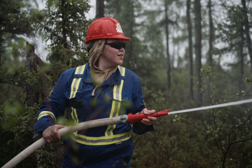
A small group of men and women clad in brightly coloured coveralls with hoses in tow wind their way through thigh-high foliage and short (by southern Canadian standards) trees on the outskirts of Kuujjuaq, the largest village in Nunavik, the Inuit homelands in Arctic Quebec. A logo emblazoned on the sleeve of many of the jumpsuits reads, “Kativik Civil Security,” which is effectively the emergency management arm of the Kativik Regional Government that delivers public services in Nunavik. The group consists mostly of firefighters, volunteer or otherwise, from communities across the region. They’re here as part of a two-day wildfire first responder course being taught by the Société de protection des forêts contre le feu, otherwise known as SOPFEU, the non-profit organization that serves as the province’s wildfire service. Firefighting instructor Frédéric Lalague gives trainees an overview of the tools of the trade. Residents of remote northern communities can’t rely on firefighters from the south to reach them quickly enough in an emergency. So, these local volunteers are learning to fight wildfires themselves. Though geographically below the Arctic Circle, the Nunavik region has a mix of Arctic and subarctic climate and straddles the treeline, where forest fades to tundra. Training to fight wildland fire in an area surrounded by lakes and covered by green vegetation beaded by droplets of rainwater may seem confusing, perhaps even more so given that this area is covered by snow and ice from November until April or May. But for Larry Shea, a firefighter in Kuujjuaq, it makes total sense. “We would like to be prepared for all eventualities,” Shea says. A structural firefighter for 25 years, Shea has recently found himself face-to-face with wildfires on the outskirts of Kuujjuaq, including one not far from where he now stands in his bright red overalls. That includes a 2023 wildfire that burned across the Koksoak River from Kuujjuaq, clearly visible to the fewer than 3,000 residents who call it home. Quebec’s wildfire service uses satellites to detect lightning strikes and assess fire risk. But its monitoring doesn’t provide any data specifically about fire risk above the 55th parallel — making it impossible for Nunavik’s 14 fly-in communities to have the types of wildfire information and precaution systems common in the south. Map: Shawn Parkinson / The Narwhal Mitch Vail, a civil security coordinator for the regional government, calls the 2023 fire “a wake-up call,” reinforcing that “These types of events can happen even in the north.” The next year, Vail reached out to SOPFEU to request training. He wasn’t alone. Quebec’s record-breaking 2023 wildfire season saw 4.5 million hectares burn, an all-time record for the province. The following year, the number of training requests exploded. “I think 2023 opened a lot of people’s minds to the threat of wildfire,” SOPFEU liaison agent Frédéric Lalague says. Though he predominantly works with Indigenous communities across the province, he was on the fire lines in 2023. “I think we all kind of remember where we were,” says Lalague, of the day fires exploded across the province. “We were geared up to maybe fight, you know, 30 to 40 fires at the same time, or one major fire … we had, I think, close to 150 ignitions in one day.” With about 2,700 residents, Kuujjuaq is the largest of Nunavik’s 14 communities, all of which are fly-in only. In wildfire fighting, logistics “is the name of the game,” Lalague says. In Quebec, SOPFEU responds to major wildfires, but in Nunavik, the logistics of using firefighters from outside the region quickly become complicated. All 14 communities are fly-in only, which means no ability to transport heavy, trailer-based firefighting equipment. It also means increased travel time for southern-based firefighters to get to the North and raises questions about where those firefighters would sleep, what they would eat and what they would drink when they got there. Of course, the challenges for getting people and equipment into Nunavik communities also extend to getting people out. In Nunavik, it’s not only fires that can prompt emergency evacuations, but also community-wide issues with water supplies or power, which comes from diesel generators. “If we’re in the south, you get in your vehicle and you drive to the next community,” Vail says. “It’s not an option here.” While the Kativik Regional Government is developing an evacuation model for communities, Vail says it’s also looking at potentially creating designated sites in or near communities that would be safe from wildfires. Ultimately, the ideal situation is to avoid all of these complicated scenarios. That’s why SOPFEU is here: the plan is to give each community in Nunavik the training and equipment needed to act as wildfire first responders that could contain and extinguish a fire or, at the very minimum, buy some time until southern reinforcements arrive. Satellite monitoring doesn’t assess wildfire risk as far north as Nunavik The Kuujjuaq-based course consists of one day in the classroom and one in the field. Last summer, it was offered to communities located in the treeline: the southern edge of the region, where warmer conditions allow for more vegetation, making the threat of wildfire higher. Each community was given hoses and pumps and trained on how to use them. This year, treeline communities that couldn’t attend were invited back, and an invitation was extended to fire departments above the treeline, too. Firefighting capability farther north is important, because even tundra is vulnerable to wildfire. The treeless tundra, which is largely characterized by ground-hugging vegetation like mosses, lichens and small plants “can be very volatile,” Vail says. “It can still cause significant damage.” In August 2023, a tundra fire threatened Bathurst Inlet, Nvt., a seasonal community roughly 320 kilometres east of Kugluktuk, prompting a state of emergency and evacuation order. Had nobody been in Bathurst Inlet to report the fire, there’s a chance it would have consumed the site, which includes a lodge, cabins and a former Hudson’s Bay trading post. Given the remoteness of areas where tundra fires occur, spotting them at all is a challenge and is often only possible via remote sensing. They’re not a regular occurrence in Canada, but researchers now think they happen more than previously believed. According to satellite data from NASA and the United States Geological Survey, there were roughly 70 recorded tundra fires in Canada between 1986 and 2022. But last year, researchers with Natural Resources Canada’s Northern Forestry Centre published a reanalysis of that data done with new software, identifying an additional 209 fires during that 36-year time span. It’s information that helps paint a better-defined picture of what “normal” may have looked like — even as climate change makes wildfires generally less predictable, as well as bigger and hotter. According to the U.S. National Oceanic and Atmospheric Administration, 2024 was the Arctic’s second-warmest year on record, which means more hot days, but also a medley of other noticeable climate-driven changes. For Shea, this means seeing bugs, birds and animals — like moose — that he never used to. For Vail, it’s the vegetation: longer growing seasons and unfamiliar plants and trees. “If you look around, you’re probably not going to see a 200-year-old tree, but you would in the south,” he says. “The trees are moving farther north … and it’s happening faster than one might think.” Wildfires can strike above the treeline, too. A recent analysis of historical data revealed northern tundra fires are more common than previously thought. Satellites are also how SOPFEU detects everything from wildfires to lightning strikes across Quebec, including Nunavik. But its monitoring doesn’t provide any data specifically about fire risk above the 55th parallel — making it impossible for Far North communities to have the types of wildfire information and precaution systems common in the south, like a sign on the side of a highway advising passers-by of local risk level. Given that neither the treeline nor the threat of wildland fire stops at the 55th parallel, Vail is exploring how that data can be obtained, particularly given how fast conditions can change in the north. “We have a heat warning coming up,” Vail said in early July. “Three days of significant heat can really dry out the topography and really cause a more serious risk.” Originally, Vail’s plan was to offer the firefighting course for two years, which he thought would be enough time to ensure each community had a chance to receive it. Now, he believes it’s going to be an annual event, both to ensure enough community members are trained and, hopefully, to continually add to the equipment being made available. “This is a way for us to be proactive in terms of climate change, because it is going to be posing more of a risk,” Vail says. Recent Posts Decision looms for next major B.C. LNG export project By Matt Simmons (Local Journalism Initiative Reporter) Aug. 12, 2025 3 min. read B.C. concluded its environmental assessment of the Ksi Lisims LNG proposal and declined additional dispute… Wildfires happen in the Far North, too. Communities are getting ready Aug. 12, 2025 7 min. read In Nunavik’s fly-in communities, residents are becoming wildfire first responders ‘This is all disingenuous’: Ontario’s belated Bill 5 consultations fail to reassure First Nations Aug. 11, 2025 10 min. read Leaked documents show the Doug Ford government’s fast-tracking plans allow for ‘special economic zones’ and…
Wildfires happen in the Far North, too. Communities are getting ready


